Aurysia Sentinel
Multi-domain geospatial intelligence. Aircraft, ships, satellites, conflict zones, CCTV networks, and breaking events — all on one dark-ops map, updating in real time.
0+
Aircraft tracked
0+
Vessels monitored
0+
Satellites in orbit
0+
CCTV feeds
The world's data is already public.
Nobody was watching it all.
Aircraft ADS-B broadcasts, maritime AIS signals, satellite orbital data, earthquake sensors, environmental monitoring networks — a surprising amount of global telemetry is already public.
This data is scattered across dozens of tools and APIs. Sentinel combines these signals into a single interface — a unified dark-ops map that reveals the full picture in real time.
Sentinel does not introduce new surveillance capabilities. It aggregates and visualizes existing public datasets. Fully auditable. No user data collected. Runs entirely in your browser.
Every signal.
One map.
Aviation Tracking
- ›5,000+ commercial flights via OpenSky Network
- ›Private jets with owner identification
- ›Military aircraft — tankers, ISR, fighters via adsb.lol
- ›ACARS datalink telemetry surfaced in aircraft dossiers
- ›Cumulative fuel burn & CO₂ per flight, not hourly estimates
- ›Per-flight source attribution: adsb.lol, OpenSky, airplanes.live, adsb.fi
- ›Holding pattern detection & flight trail accumulation
Maritime Intelligence
- ›25,000+ vessels via AIS WebSocket in real time
- ›All 11 US Navy carrier strike groups tracked
- ›OSINT-estimated positions from GDELT news scraping
- ›Cargo, tanker, passenger, yacht, military classification
- ›Global Fishing Watch vessel events — fishing activity worldwide
- ›AIS failover — AISHub REST fallback keeps the layer alive during outages
- ›Clustered display with zoom-based decluttering
Space & Satellites
- ›2,000+ active satellites via CelesTrak TLE + SGP4
- ›Mission-type classification: recon, SAR, SIGINT, nav
- ›NASA MODIS daily true-color imagery with time slider
- ›Sentinel-2 on-demand at 10m resolution
- ›TinyGS LoRa satellite constellation tracking
- ›SatNOGS ground station network with live observation data
Geopolitics & Conflict
- ›GDELT — 1,000 conflict events every 8 hours
- ›Ukraine frontline via DeepState Map GeoJSON
- ›20 OSINT RSS sources with priority weights
- ›Right-click region dossier: head of state, Wikipedia, profile
- ›Country-level intelligence cards on demand
Surveillance Mesh
- ›11,000+ live traffic cameras from 13 sources across 6 countries
- ›TfL, NYC DOT, Austin, Singapore, Spanish networks
- ›Auto-detection: video, MJPEG, HLS, embed feeds
- ›Custom URL ingestion for private cameras
- ›Clustered green markers with zoom-based reveal
Signal Intelligence
- ›500+ KiwiSDR receivers plotted worldwide
- ›Live radio tuner embedded in SIGINT panel
- ›GPS jamming detection via aircraft NAC-P analysis
- ›Grid-based interference zone mapping
- ›Severity labels: GPS JAM XX% on red overlays
Environmental Monitoring
- ›NASA FIRMS — 5,000+ fire hotspots per cycle
- ›NOAA space weather with Kp index color coding
- ›Smithsonian GVP Holocene volcanoes plotted worldwide
- ›NOAA severe weather polygons with urgency/severity indicators
- ›OpenAQ PM2.5 stations with real-time air quality readings
- ›USGS real-time earthquake feed with magnitude scaling
Visual Modes & Workspace
- ›DEFAULT, SATELLITE, FLIR, NVG, CRT style presets
- ›Persistent dashboard state — layers, filters, and panels restored on reload
- ›Day/night cycle solar terminator overlay
- ›Point-to-point distance & bearing measurement
- ›LOCATE bar — fly to coordinates or place names
- ›Global markets ticker (minimizable)
Privacy & Transparency
- ›100% open-source — fully auditable
- ›No user data collected or transmitted
- ›Runs entirely in your browser + self-hosted backend
- ›Only aggregates existing public datasets
- ›No new surveillance capabilities introduced
SAR Ground-Change Detection
- ›Synthetic Aperture Radar — detects changes through cloud cover, at night
- ›Mode A: Free Sentinel-1 scene metadata, no account required
- ›Mode B: NASA OPERA (DISP, DSWx, DIST-ALERT) + Copernicus EGMS anomalies
- ›Deformation (mm-scale), flood extent, vegetation disturbance, blast craters
- ›Color-coded pins: orange deformation, cyan water, green vegetation, red damage
- ›AOI editor — define watch areas directly on the map
Infrastructure & Environment
- ›Global military installation and missile facility database
- ›35,000+ global power plants from WRI database
- ›2,000+ data centers mapped with operator identification
- ›Undersea submarine cable routes — the physical internet backbone
- ›Smithsonian GVP Holocene volcanoes worldwide
- ›OpenAQ PM2.5 air quality + NOAA severe weather polygons
- ›Internet outage monitoring via Georgia Tech IODA
AI Command Channel — OpenClaw
- ›Bidirectional agentic bridge — any HMAC-SHA256 signed agent connects
- ›Batch concurrent execution: up to 20 commands in one request
- ›Full access to 60+ data sources with enriched geo data
- ›Agent parity with the map — search_telemetry, osint_lookup, entity_expand, osint_sweep
- ›AI Intel Pins — 14 categories, confidence scores, TTL expiry
- ›WebSocket token auth and fetch-health monitoring on every agent shell
- ›Sovereign Shell participation: petition, vote, stake — programmatically
Time Machine — Snapshot Playback
- ›Media-style transport for the entire telemetry feed
- ›Live ↔ Snapshot toggle with instant polling pause
- ›Hourly index — jump to any captured timestamp from the scrubber
- ›Frame interpolation for aircraft, ships, and satellites
- ›Variable playback speed: step, play, fast-forward, rewind
- ›Operator-side storage — no third party sees your timeline
InfoNet Sovereign Shell
- ›Petitions + Governance DSL — on-chain parameter changes by vote
- ›Upgrade-Hash Governance — 80% supermajority, 40% quorum, 67% Heavy-Node
- ›Resolution & Dispute Markets — stake on outcomes, open bonded disputes
- ›Bootstrap: first 100 markets resolve via one-vote-per-eligible-node
- ›Two-tier state + epoch finality with CRDT propagation
- ›Privacy primitive runway — anonymous citizenship proofs, locked protocol contracts
Recon & Threat Intelligence
- ›Server-side OSINT toolkit — IP geolocation, DNS, WHOIS, certificate transparency
- ›BGP/ASN lookups and SSRF-guarded subnet scanning via Shodan InternetDB
- ›OFAC sanctions screening through OpenSanctions
- ›CVE lookups cross-referenced with the CISA Known Exploited Vulnerabilities feed
- ›Malware C2 hotspots from abuse.ch Feodo Tracker and URLhaus
- ›Entity graph expansion linking Wikidata relationships to sanctions data
- ›Supply-chain risk overlay — semiconductor and battery plants vs. conflict and disaster zones
Telegram OSINT
- ›Hourly public channel scraping from war and OSINT sources
- ›Keyword-based risk scoring for rapid threat triage
- ›Metro-anchor geocoding kept separate from news centroids
- ›Incremental merge — no redundant re-scraping between cycles
- ›Inline photo and video proxied through the backend
- ›Source-language popup labels with Persian right-to-left support
Encrypted Mesh Comms
- ›MLS-encrypted gate rooms on private InfoNet hashchains
- ›Gate members hold the only keys — swarm replication stays opaque
- ›Ratchet-encrypted direct messages over Tor and wormhole transport
- ›Short wormhole addresses exchanged out-of-band, with contact approval
- ›Cross-node DM replication while peers are offline, with anti-spam limits
- ›Dead Drop token-based epoch mailboxes and Meshtastic radio bridging
What you can do with Sentinel.
Real-time global intelligence at your fingertips.
Track any aircraft in real time
From Air Force One to private jets of billionaires, dictators, and corporations. Real-time positions, flight trails, holding patterns, and owner identification.
Monitor satellites overhead
See which satellites pass over any location. Mission-type classification: military recon, SAR, SIGINT, navigation, early warning. High-res imagery on demand.
Watch naval traffic worldwide
Track 25,000+ vessels including all 11 US carrier strike groups. OSINT-estimated positions from automated news intelligence and AIS feeds.
Detect GPS jamming zones
Real-time analysis of aircraft navigation accuracy to identify interference zones. Grid-based aggregation with severity ratings and red overlay mapping.
Listen to emergency scanners
Tune into 500+ public SDR receivers worldwide. Monitor emergency frequencies, ATC, and maritime channels directly in-browser.
Follow natural disasters live
Earthquakes, wildfires, space weather events — all in real time with severity visualization. 5,000+ fire hotspots per cycle from NASA FIRMS.
InfoNet — Decentralized intelligence mesh
The first decentralized intelligence communication layer in an OSINT platform. Obfuscated message relay, gate personas with Ed25519 signing, Meshtastic radio integration, and Dead Drop peer-to-peer exchange. No accounts, no signup, no identity required.
Shodan device search
Query Shodan directly from Sentinel. Search by keyword, CVE, port, or service — results plotted as a live overlay on the map with configurable markers for shape, color, and size.
Track rail networks in real time
Amtrak trains across the US with speed, heading, route, and status. European rail via DigiTraffic integration. All positions rendered live on the map.
Detect ground changes from space
SAR Ground-Change Detection using NASA OPERA and Copernicus EGMS. Subsidence, flood extent, deforestation, blast craters — detected through cloud cover, at night, anywhere on Earth.
Replay the world at any timestamp
Time Machine lets you scrub, pause, and replay the entire telemetry feed. Step through captured snapshots with frame interpolation for aircraft, ships, and satellites.
Command AI agents to analyze for you
The AI Command Channel bridges any compatible LLM agent — Claude, GPT, LangChain — directly into Sentinel's 60+ data sources. Agents place pins, control the map, and participate in InfoNet governance.
Score geopolitical risk by region
GT Analytics turns raw feeds into strategic assessment — regional risk scoring computed by OpenClaw and painted straight onto the map as a live overlay.
Unmask the infrastructure behind a signal
Resolve an IP to its ASN, owner, certificates, and open ports. Screen entities against OFAC sanctions, pivot through Wikidata relationship graphs, and cross-check CISA KEV.
Map what war channels are reporting
Public Telegram channels scraped hourly, risk-scored by keyword, geocoded to metro anchors, and pinned to the map with inline media — in the source language.
See it in action.
Real screenshots. Real data.
Every image below is a real capture from Sentinel — no mockups, no renders.
Sentinel Overview — May 2026
Updated dashboard with InfoNet mesh, Shodan device overlays, and rail tracking — captured May 10th, 2026
Live Maritime Intelligence
Zoomed satellite view of the Seine in Paris — live vessel tracking with detail panels
News Intelligence Layer
Area-based news overlays surfacing critical events on the map
Aviation & Satellite Tracking
Commercial flights, military aircraft, and orbital assets in a single view
Live CCTV — London
One of 11,000+ live traffic camera feeds available worldwide
Sentinel SIGINT.
Wireless OSINT & Signal Intelligence.
Discover, map, and analyze every radio-based device around you — passively. Wi-Fi networks, Bluetooth devices, vehicle RF signatures, IP cameras, cell towers, and IoT appliances. All plotted on the map in real time, without active intrusion.
Integrates with Wigle.net, wpa-sec, OpenCellID, and Shodan for cross-referenced intelligence. Identifies leaked Wi-Fi credentials via k-Anonymity queries.
Explore SIGINT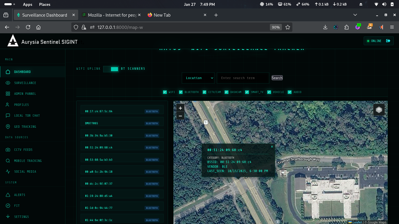
Analytics. Recon. Encrypted mesh.
From raw telemetry to reasoned assessment.
The releases since v0.9.7 push Sentinel past collection. Geopolitical risk scoring turns feeds into assessments, a full reconnaissance toolkit resolves entities behind the signals, Telegram becomes a first-class mapped source, and the mesh layer gains end-to-end encrypted rooms and direct messages.
GT Analytics & Strategic Risk
OpenClaw-powered geopolitical analytics with regional risk scoring rendered as map overlays — reading the telemetry, not just plotting it.
Osiris Recon Toolkit
IP, DNS, WHOIS, certificate transparency, BGP/ASN, OFAC sanctions, CISA KEV, malware C2 feeds, entity graphs, and a supply-chain risk overlay.
Telegram OSINT
Hourly public channel scraping with keyword risk scoring, metro-anchor geocoding, inline media, and source-language labels including Persian RTL.
Encrypted Gates & DMs
MLS-encrypted gate rooms on private InfoNet chains and ratchet-encrypted direct messages over Tor and wormhole addressing.
Your data.
Your intelligence layer.
Sentinel is designed to be extended. Governments, defense contractors, and enterprises can plug in their own proprietary data sources, classified feeds, and internal sensor networks — transforming Sentinel into a fully customized intelligence operations center.
Self-hosted deployment on your infrastructure — air-gapped capable
Role-based access control with audit logging
Custom data connectors — plug in any API, sensor, or feed
White-label branding for your organization
Multi-analyst collaboration with shared map sessions
No sales team, no SDR queue — you reach the engineer who builds Sentinel.
See everything.
Miss nothing.
Sentinel is available for qualified analysts, researchers, and enterprise teams.